
I hope I'm not losing my "edge," but, I actually waited almost 5 days before driving across the new East Span of the San Francisco-Oakland Bay Bridge.
The Bridge reopened late on Labor Day evening (September 2), after a very long Labor Day weekend closure (5 days) for final touches to connect the new East Span to the Yerba Buena/Treasure Island tunnel and the West Span of the bridge, which has remained intact.
The Bay Bridge opened for traffic in November, 1936; that's nearly 76 years ago. It is 6 months older than the more-famous Golden Gate Bridge, which connects San Francisco with Marin County. For just about all of this time, the Bay Bridge has been a true workhorse of a bridge, carrying close to 300,000 vehicles each day, between San Francisco and Oakland. It has two spans, connected in the middle by a tunnel that has exits to Yerba Buena and Treasure Islands. The west span is a double-deck suspension bridge. The east span has been, until this past week, a two-level cantilever bridge.
During the Loma Prieta Earthquake in 1989, a portion of the east span of the Bay Bridge collapsed. It was repaired, but it indicated that the bridge was not sufficiently seismically strong enough to sustain future earthquakes.
Finally, nearly 24 years later and a lot of politics and "challenges", the Bay Bridge now has a magnificent new east span.
This new span cost a lot of money and some say it did not have to be such an architecturally-interesting structure, but, I predict, the criticisms will soon be forgotten and this magnificent Bay Bridge will become another San Francisco Bay Area icon.
And, it is as seismically safe as a structure can be, anywhere.
So, Saturday was my day to drive over the new Bay Bridge.
Jim and I left the house at 8:30 a.m. and went through the toll plaza at 8:46 a.m. We left early in an attempt to avoid the heavy traffic that has been on the bridge since it opened. Our drive was as perfect as it could be.

We've been having a heat wave in the Bay Area and Saturday was one of those rare warm sunny days in all parts of San Francisco, even on the very western edge of the City, which was our destination for the day.
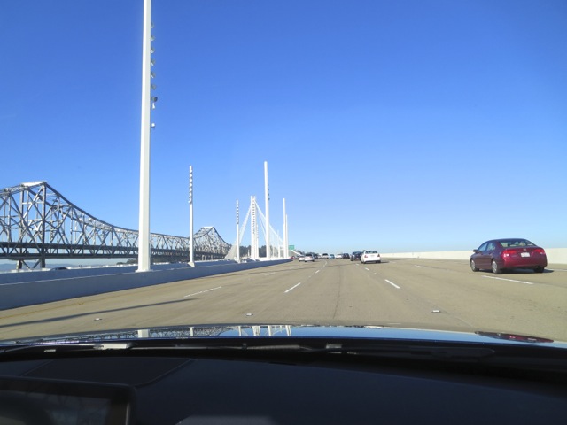
The new east span is very open and consists of one level, with separate parallel roadways going west and east.
I drove and Jim was my camera person. We had the sunroof open so he could take upward pictures of the cathedral-like tower.
These photos chronicle our drive:




This is the Yerba Buena Tunnel entrance, going west, at the end of the east span. It connects to the west span of the Bay Bridge and has an exit to both Treasure Island and Yerba Buena Island:

Here are a few views of the west span of the Bay Bridge, as we drove west toward San Francisco. Notice that it has a straighter approach across it.


On the way back to the East Bay, leaving San Francisco, you can see the old Bay Bridge east span on your right. Having crossed this bridge hundreds of times, I've never really had a good look at it...to me it looks like an old railroad bridge, which, for a time it was when the Key Line went over the Bay Bridge into San Francisco.


There is a bicycle/walking path parallel to the east-bound side of the Bay Bridge's east span, on its south side.

It is a temporary structure, for the time being, until about 3 years from now when the old east span will be totally removed. Eventually, the permanent path will go all the way to Treasure Island where there are at least 8 wineries, a nice deli, housing, and fabulous views of both San Francisco and the East Bay. For now, the temporary path ends before the Yerba Buena Tunnel.
**********

And, what did we do once we got to San Francisco?
We drove across the City as far west as one can drive before driving into the Pacific Ocean, to spend much of the day at Land's End, which is part of the Golden Gate National Parks Conservancy.
Land's End is in the northwest corner of San Francisco. It has miles of semi-rugged trails, some portions paved, with breathtaking views of the Golden Gate Bridge, the Pacific Ocean, many small beaches, old shipwrecks, the ruins of Sutro Baths, and passing freighters and other boats.
We hiked at my leisurely pace for several hours, going from the fairly-new Land's End Lookout Visitor Center, along the Coastal Trail to the parking area at El Camino del Mar, another entrance to Land's End. We parked in the large free parking lot at the Visitor Center.
Some of you will recall that I blogged about Land's End about a year ago, shortly after the Visitor Center first opened.
We started here.

Jim is off and hiking.

One of many stops to enjoy the views.

At the Eagle's Point Overlook looking out at the Golden Gate Bridge and China Beach.


Zooming in on the Cliff House

and rocks that often have seals on them, but seemed to just be inhabited by birds on this day.

After all this, we were famished. Lunch at Louis' seemed to be the thing to do.
Although Louis' has been in business here since 1937, this was my first time at this small, very popular restaurant that serves breakfast, lunch and dinner every day.
I've looked in before or after a meal at one of the Cliff House dining rooms, and, last time at the Cliff House, decided that I had to eat at Louis' where the menu is similar to that at the Cliff House's casual Bistro dining room, but less expensive, more popular with locals than with tourists, and with just as fabulous views.
Louis' boasts that they have only taken cash payments since 1937 and continue to do so. So, bring cash, or your ATM card (they have an ATM right in the restaurant).
We were happy with our lunch here and even with the congenial wait outside on this warm day.

Jim, of course, had the Shrimp Louis salad.

And, I could not resist the Tuna Melt.


