Tuesday, September 24, 2013

28th Sausalito Floating Homes Tour


Once a year, for the last 28 years, the Floating Homes Association in Sausalito, California, holds its Floating Homes Tour. Each year a different set of homes is open to the public.  To quote the current president of the Floating Homes Association on how the ticket proceeds are used, "We share our tour proceeds with our neighbors, the Friends of the Marin City Library, Sausalito Village and other deserving organizations."

To celebrate her birthday this year, Debbie asked me to take her to the Floating Homes Tour. It sounded like a fun way to spend a day together, so, we reserved our tickets, and off we went last Saturday.

As luck would have it, after a glorious summer, on this, the last day of summer, it started raining (I should say "pouring") about 5 minutes after we set out on our one-hour drive to Sausalito. And, it didn't stop raining until sometime in the afternoon.  Given that the tour is on just one day, from 11 a.m. until 4 p.m., we, and several hundred others, forged on through the rain and mud.

Most of us have called the floating homes "houseboats," but their official description in the Sausalito community is "floating homes" because these homes no longer set sail; they are permanently anchored.

This year's tour included 4 arks and 10 floating homes.  For more terminology: arks are boats that do not float; they are permanently secured on pilings at the edge of the water. In contrast to the floating homes, the arks do not sway or rise and fall with changing tides and currents.

The tour is self-guided and, this year featured homes on three different docks, all within walking distance of one another.

Many of the home owners were in their homes to greet visitors and to answer questions. Docents from the Floating Homes Association and historians were everywhere to provide more information and insights. Seeing this community up close was interesting and a lot of fun. It also gave me, who thrives in clutter in my own home, a lesson in living small (Even the most luxurious and modern of floating home has extremely limited storage space.

This rest of this blog will mainly be photos of the homes we visited or walked past.

By the way, those who come to this tour every year swore that this is the first year that they've had rain. So, mark your calendar for next year and keep checking the Floating Homes Association website for the date and ticket information for the 2014 tour.

Debbie on a bridge in the Appleton Ark's enclosed deck; there is a koi pond below.


The Blue Heron, on Main Dock, has a very modern interior.


The bedrooms in the S.S. Maggie, on South Forty Pier, are on the bottom level of the home. This is the guest room, built into the bow of the boat. The original hull is still visible. The S.S. Maggie was built around 1890 as a steam schooner and retired in the 1930s.


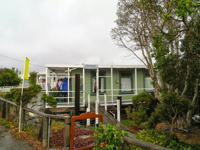
The Mayflower is another ark. It was under construction at the time of the 1906 Earthquake and was completed and launched in 1907.  It has been on pilings in this slip since sometime between 1920 and 1930.


The Winchester Mystery Boat on the Main Dock is relatively new, having been built in the 1960s.


We were constantly amused and surprised by the fanciful and beautiful homes we passed.


The "front yards" of the homes is along the walkways that traverse each dock. It is where owners store some of their belongings and where they have their gardens.


The water views between docks and out onto Richardson Bay give another perspective on the community.


Monday, September 9, 2013

Crossing the new East Span of the Bay Bridge on a Sunny Warm SF Day


I hope I'm not losing my "edge," but, I actually waited almost 5 days before driving across the new East Span of the San Francisco-Oakland Bay Bridge.

The Bridge reopened late on Labor Day evening (September 2), after a very long Labor Day weekend closure (5 days) for final touches to connect the new East Span to the Yerba Buena/Treasure Island tunnel and the West Span of the bridge, which has remained intact.

The Bay Bridge opened for traffic in November, 1936; that's nearly 76 years ago. It is 6 months older than the more-famous Golden Gate Bridge, which connects San Francisco with Marin County.  For just about all of this time, the Bay Bridge has been a true workhorse of a bridge, carrying close to 300,000 vehicles each day, between San Francisco and Oakland.  It has two spans, connected in the middle by a tunnel that has exits to Yerba Buena and Treasure Islands. The west span is a double-deck suspension bridge. The east span has been, until this past week, a two-level cantilever bridge.

During the Loma Prieta Earthquake in 1989, a portion of the east span of the Bay Bridge collapsed.  It was repaired, but it indicated that the bridge was not sufficiently seismically strong enough to sustain future earthquakes.

Finally, nearly 24 years later and a lot of politics and "challenges", the Bay Bridge now has a magnificent new east span.

This new span cost a lot of money and some say it did not have to be such an architecturally-interesting structure, but, I predict, the criticisms will soon be forgotten and this magnificent Bay Bridge will become another San Francisco Bay Area icon.

And, it is as seismically safe as a structure can be, anywhere.

So, Saturday was my day to drive over the new Bay Bridge.

Jim and I left the house at 8:30 a.m. and went through the toll plaza at 8:46 a.m. We left early in an attempt to avoid the heavy traffic that has been on the bridge since it opened.  Our drive was as perfect as it could be.


We've been having a heat wave in the Bay Area and Saturday was one of those rare warm sunny days in all parts of San Francisco, even on the very western edge of the City, which was our destination for the day.

The new east span is very open and consists of one level, with separate parallel roadways going west and east.

I drove and Jim was my camera person. We had the sunroof open so he could take upward pictures of the cathedral-like tower.

These photos chronicle our drive:


This is the Yerba Buena Tunnel entrance, going west, at the end of the east span. It connects to the west span of the Bay Bridge and has an exit to both Treasure Island and Yerba Buena Island:

Here are a few views of the west span of the Bay Bridge, as we drove west toward San Francisco. Notice that it has a straighter approach across it.


On the way back to the East Bay, leaving San Francisco, you can see the old Bay Bridge east span on your right.  Having crossed this bridge hundreds of times, I've never really had a good look at it...to me it looks like an old railroad bridge, which, for a time it was when the Key Line went over the Bay Bridge into San Francisco.


There is a bicycle/walking path parallel to the east-bound side of the Bay Bridge's east span, on its south side.


 It is a temporary structure, for the time being,  until about 3 years from now when the old east span will be totally removed.  Eventually, the permanent path will go all the way to Treasure Island where there are at least 8 wineries, a nice deli, housing, and fabulous views of both San Francisco and the East Bay. For now, the temporary path ends before the Yerba Buena Tunnel.

**********


And, what did we do once we got to San Francisco?

We drove across the City as far west as one can drive before driving into the Pacific Ocean, to spend much of the day at Land's End, which is part of the Golden Gate National Parks Conservancy.

Land's End is in the northwest corner of San Francisco. It has miles of semi-rugged trails, some portions paved, with breathtaking views of the Golden Gate Bridge, the Pacific Ocean, many small beaches, old shipwrecks, the ruins of Sutro Baths, and passing freighters and other boats.

We hiked at my leisurely pace for several hours, going from the fairly-new Land's End Lookout Visitor Center, along the Coastal Trail to the parking area at El Camino del Mar, another entrance to Land's End. We parked in the large free parking lot at the Visitor Center.

Some of you will recall that I blogged about Land's End about a year ago, shortly after  the Visitor Center first opened.

We started here.


Jim is off and hiking.


One of many stops to enjoy the views.


At the Eagle's Point Overlook looking out at the Golden Gate Bridge and China Beach.


Looking down on the Sutro Baths ruins and the Cliff House off in the distance, to the right.


Zooming in on the Cliff House


and rocks that often have seals on them, but seemed to just be inhabited by birds on this day.


After all this, we were famished. Lunch at Louis' seemed to be the thing to do.

Although Louis' has been in business here since 1937, this was my first time at this small, very popular restaurant that serves breakfast, lunch and dinner every day.

I've looked in before or after a meal at one of the Cliff House dining rooms, and, last time at the Cliff House, decided that I had to eat at Louis' where the menu is similar to that at the Cliff House's casual Bistro dining room, but less expensive, more popular with locals than with tourists, and with just as fabulous views.

Louis' boasts that they have only taken cash payments since 1937 and continue to do so.  So, bring cash, or your ATM card (they have an ATM right in the restaurant).

We were happy with our lunch here and even with the congenial wait outside on this warm day.


Jim, of course, had the Shrimp Louis salad.


And, I could not resist the Tuna Melt.